A listing shows you the best of a home. HouseLens shows you the record behind it,
pulled from official sources and our own agent data, laid out on the page you are already on.
Address26, Hampstead Grove, London, NW3 6SPVERIFIED
Size8,516 ft² · £2,642/ft²791 m² · £28,438/m²
TenureFreehold
EPCE
Council taxBand H
Sold£1.90M · 2016
Listed buildingGrade II
Conservation areaYes
Article 4Yes
Broadband1 Gbitgigabit-capable
Crime6/10
Deprivation9/10
Income10/10
Degree-educated67%
FloodSome risk nearby
Air qualityModerate
Days on market62
10 Primary0 Secondary18 Private
Nearest primaryNew End Primary School (good, 0.1 mi)
Nearest secondaryWilliam Ellis School (requires improvement, 1.2 mi)
StationHampstead Station (0.1 mi)
SupermarketSainsbury’s (0.2 mi)
GP surgeryKeats Group Practice (0.4 mi)
GymUCS Active (0.4 mi)
Eating out15 cafés · 85 restaurants
Local sell time~155 days
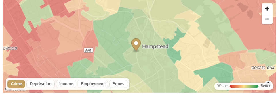
Area heat map
Verified address
The exact address, worked out from the postcode, street and property details and cross-checked against EPC and Land Registry records before it is marked Verified.
Size & £ per ft²
Floor area with the price per square foot, so you can compare like with like.
Tenure
Freehold or leasehold, stated plainly up front.
EPC rating
The property’s energy rating, from the EPC register.
Council tax band
The band that sets the annual bill on this home.
Last sold price
What this home last sold for, from HM Land Registry, not the asking price.
Planning constraints
Listed status, conservation area and Article 4: the limits on what you can change.
Broadband
Gigabit availability on the street, from Ofcom.
Neighbourhood scores
Crime, deprivation, income and education, from police.uk and government data.
Flood risk
Surface water and river flood risk, from the Environment Agency.
Air quality
A local air-quality rating for the surrounding area.
Days on market
How long this listing has been live.
Schools nearby
Counts by phase: primary, secondary and private, within reach.
Nearest schools
The closest primary and secondary, with Ofsted ratings and distance.
Nearest station
Your closest rail link and how far it is.
Everyday amenities
Supermarket, GP, gym and places to eat, each with a walking distance.
Local sell time
The typical time properties take to sell in this area.
Agent ranking
Where this agent ranks among everyone selling in NW3, from real sales-performance data.
Act on it
Jump straight to the area profile or the top-ranked local agents nearby.
Area heat map
Crime, deprivation, income, employment and prices shaded across the surrounding area. Toggle any layer.
Pillar one
The real numbers
Asking prices are a starting position. HouseLens shows you what homes on the street have actually sold for, taken straight from HM Land Registry, so you can judge an asking price against reality.
Sold-price history for the street and the property
Price per square foot and floor area
How the asking price compares to recent sales nearby
Free to view, no metering on the figures
21 Sanford Terrace£1.42m · 2019
19 Sanford Terrace£1.18m · 2017
25 Sanford Terrace£1.51m · 2021
Street £/ft²£842 median
Address21 Sanford Terrace Verified
TenureFreehold
EPCD (current 62)
Council taxBand F
Pillar two
The verified property
Portals hide the full address on most listings. HouseLens recovers it, then confirms it against the EPC certificate before showing it as verified, so the details you see belong to the actual home, not a neighbour.
Exact address recovered and EPC-matched
Tenure, energy rating and running-cost context
Council tax band for the property
Honest confidence labelling when a match is not certain
Pillar three
The area, honestly
A home is only as good as the place around it. HouseLens brings together government open data so you can weigh the things that affect daily life and resale, in one calm view.
Crime levels from police.uk
Schools, with ratings and distance
Flood risk from the Environment Agency
Broadband and mobile coverage from Ofcom
Planning constraints: conservation areas, listed status, tree orders
Crime6 / 10
Nearest primaryGood · 0.3 mi
Flood riskVery low
BroadbandGigabit available
Conservation areaYes
Agent rank in N16#3 of 18
Homes sold here24 in 12 months
Average sale£892k
Typical time to sell41 days
Pillar four
Who is selling it
The agent on a listing has a track record, and AgentSeeker measures it. See how they perform in this exact area, whether you are deciding to enquire or working out who should sell your own home.
The agent's ranking in the local area
Homes sold, average price and typical time to sell
Grounded in AgentSeeker's own performance data
Helpful for buyers and sellers alike
See it on your next listing.
Add HouseLens to your browser and the panel is there the next time you open Rightmove or Zoopla.